15th Street Hill Study
Project Overview
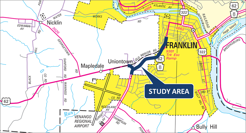
The Route 62 / Route 8 and 15th Street Hill Intersection Safety Study covers approximately one-mile along Route 8 between Gurney Road and Bell Avenue in Sandycreek Township and the City of Franklin, Venango County.
As part of the study, PennDOT, with the assistance of consultants, looked at existing and future traffic operations, safety and infrastructure conditions, identified specific needs and opportunities, and developed a series of potential improvements at the intersection and long the hillside.
Pictures and descriptions of each proposed alternative can be viewed below.
Future phases of the study will include drafting an Implementation and Funding Plan to help inform future decision-making related to transportation investments and potential project programming.
While the results of this study will help to guide future improvement opportunities throughout the study area, at this time it focuses on developing the relevant planning documentation only. Design and construction efforts are not included.
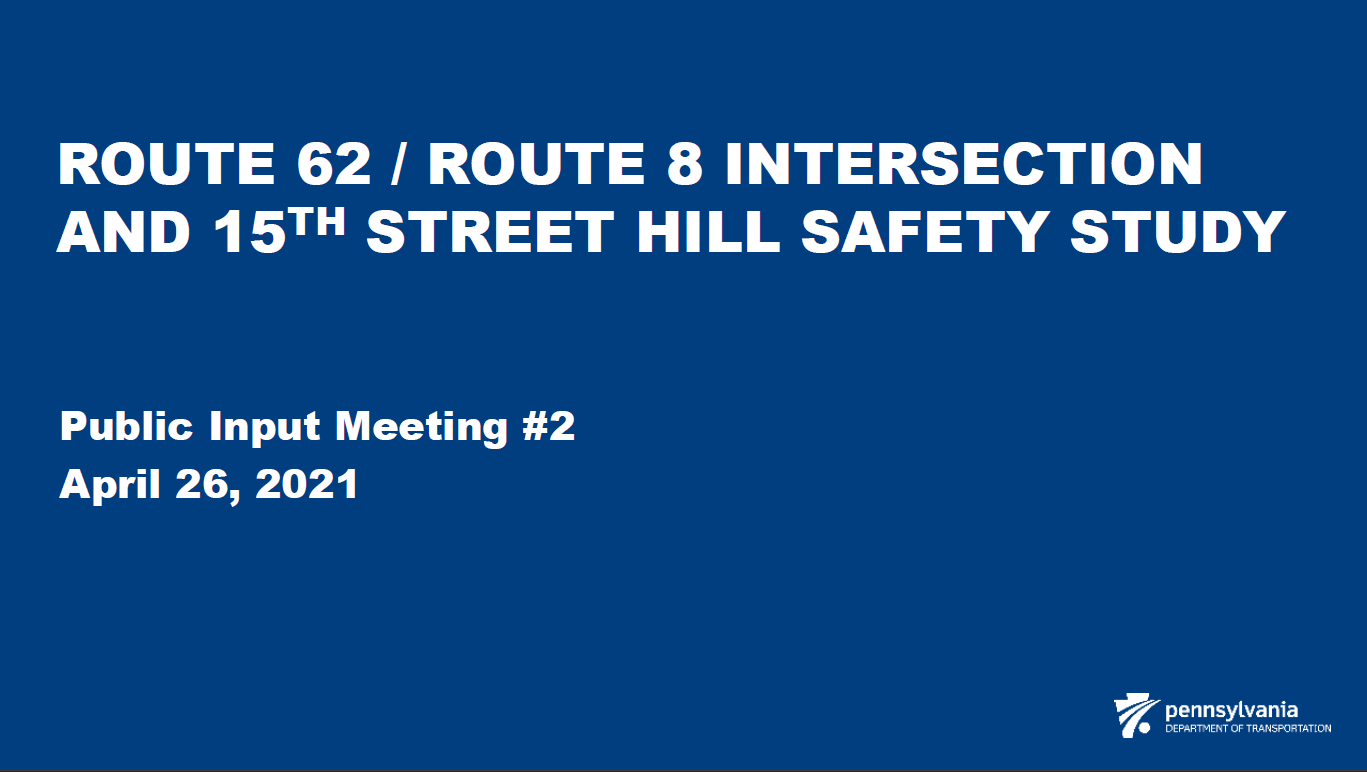
LIVE Virtual Public Meeting Opportunity
A live virtual public meeting for The Route 62 / Route 8 and 15th Street Hill Intersection Safety Study was held on Monday, April 26, 2020, from 6:00 PM to 8:00 PM. This virtual meeting included a short presentation to introduce the study, plus an opportunity for participants to directly share their evaluation of each alternative via polling questions or moderated chat-discussions with the project team.
Project Presentation
Project Alternatives
(Click on each picture to view it at a larger size.)
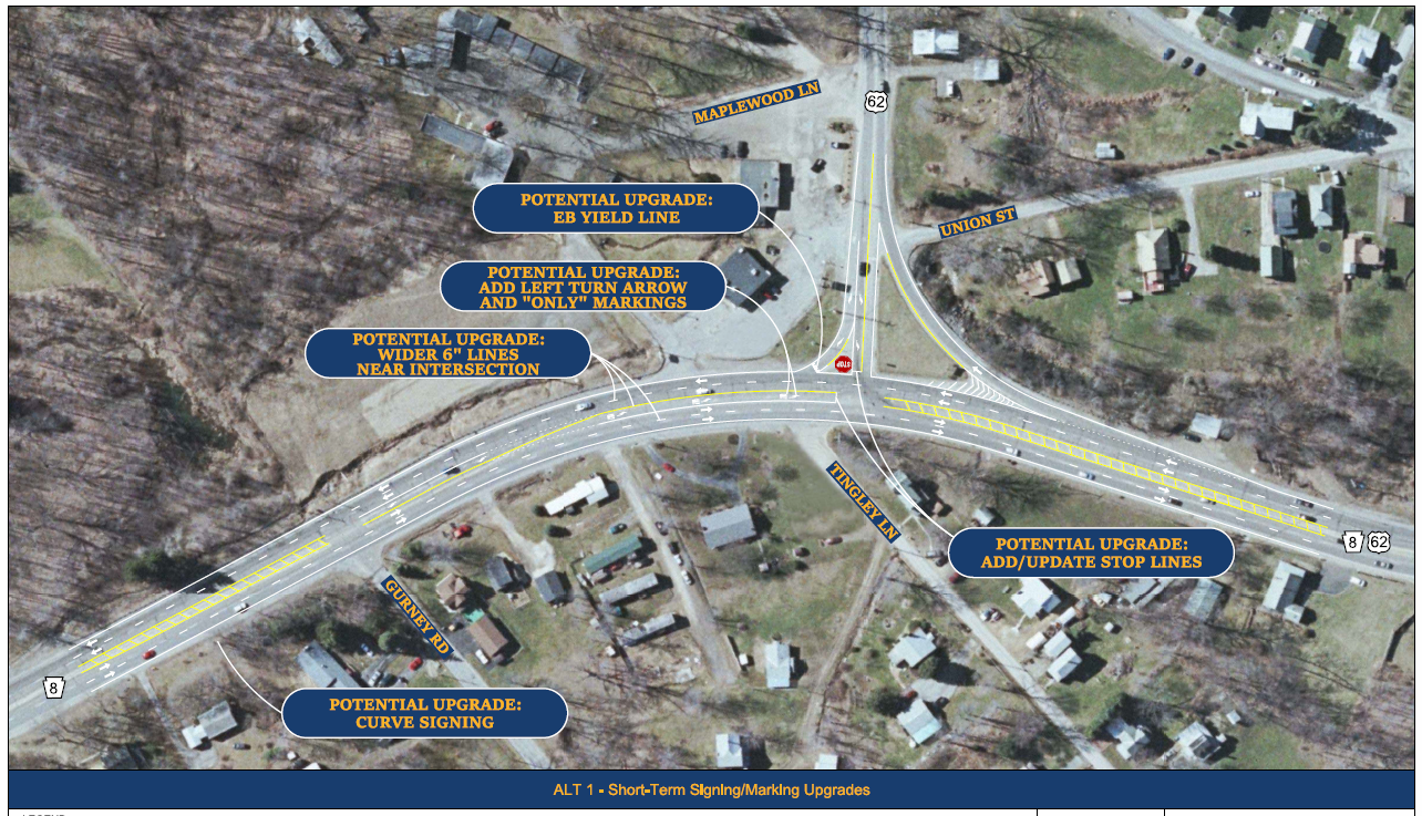
ALT 1 – This alternative upgrades signing and pavement markings through the intersection to enhance guidance and visibility for all drivers. Modifications include additional pavement markings in the existing left-turn lane from Route 8 to Route 62, clearly-identified stop and yield line locations from Route 62 to Route 8, wider lane lines along Route 8, and advance signing improvements.
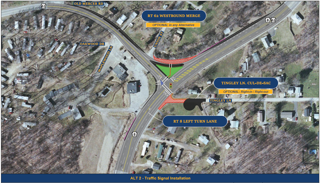
ALT 2 – This alternative includes the addition of a traffic signal at the intersection with the overall through-lanes and turn-lanes essentially unchanged from their existing conditions. Minor widening would be included to extend the existing right-turn lane for movements from Route 8 to Route 62, and to reconfigure the downstream merge area on Route 62. Tingley Lane would possibly be turned into a cul-de-sac, or at least restricted to right-in/right-out traffic only. Signalized pedestrian crosswalks would be added at different points within the intersection.
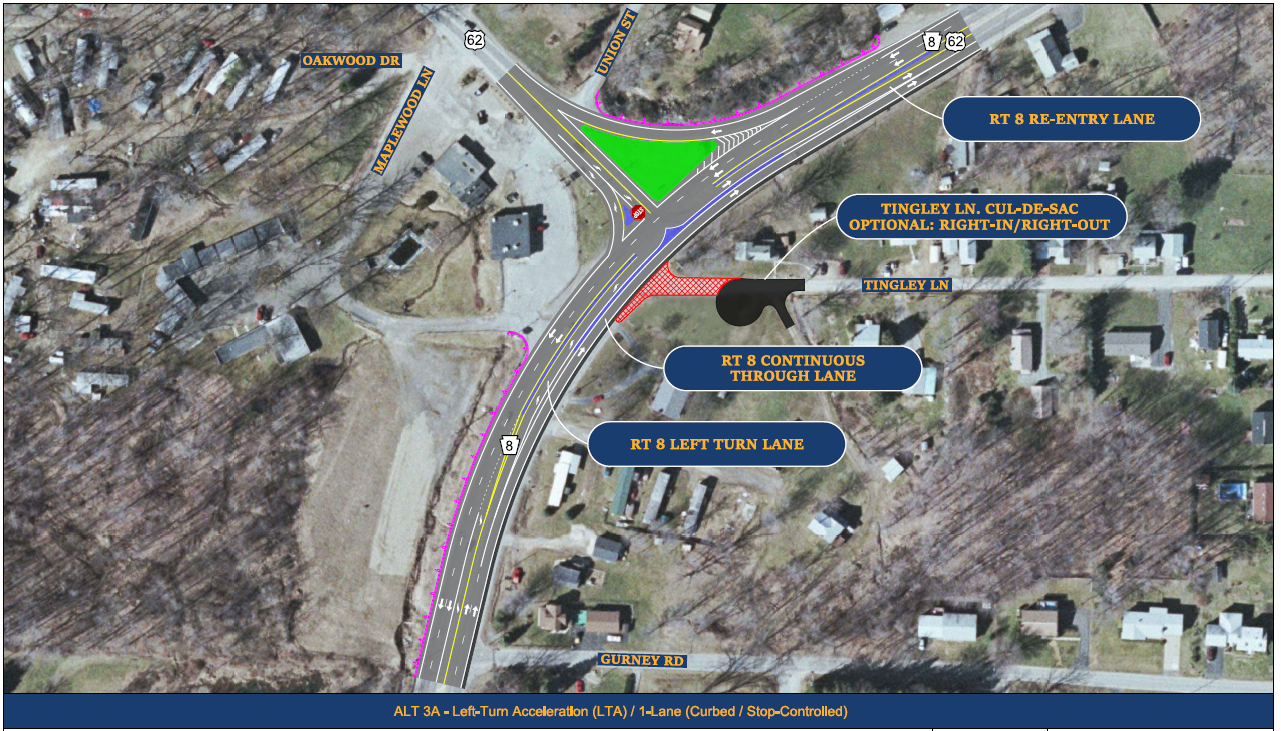
ALT 3A – This alternative installs low-curb medians to create a separate dedicated entry lane for traffic turning left from Route 62 onto Route 8. In this version, the curbing also separates Route 8 through traffic from vehicles turning left onto Route 62, while maintaining one lane of northbound Route 8 through-traffic that moves continuously through the intersection. Tingley Lane would possibly be turned into a cul-de-sac, or at least restricted to right-in/right-out traffic only.
ALT 3B – This alternative is identical to the previous ALT 3A, including the separate dedicated entry lane for traffic turning left from Route 62 onto Route 8; however, it adds a traffic signal in lieu of stop-signs to control movements for Route 62. This creates a configuration known as a Continuous Green-T intersection. The traffic signal would only control movements from Route 62, from northbound Route 8 onto Route 62, and uphill along southbound Route 8. One lane of northbound Route 8 through traffic headed down the hill would have a continuous green light.

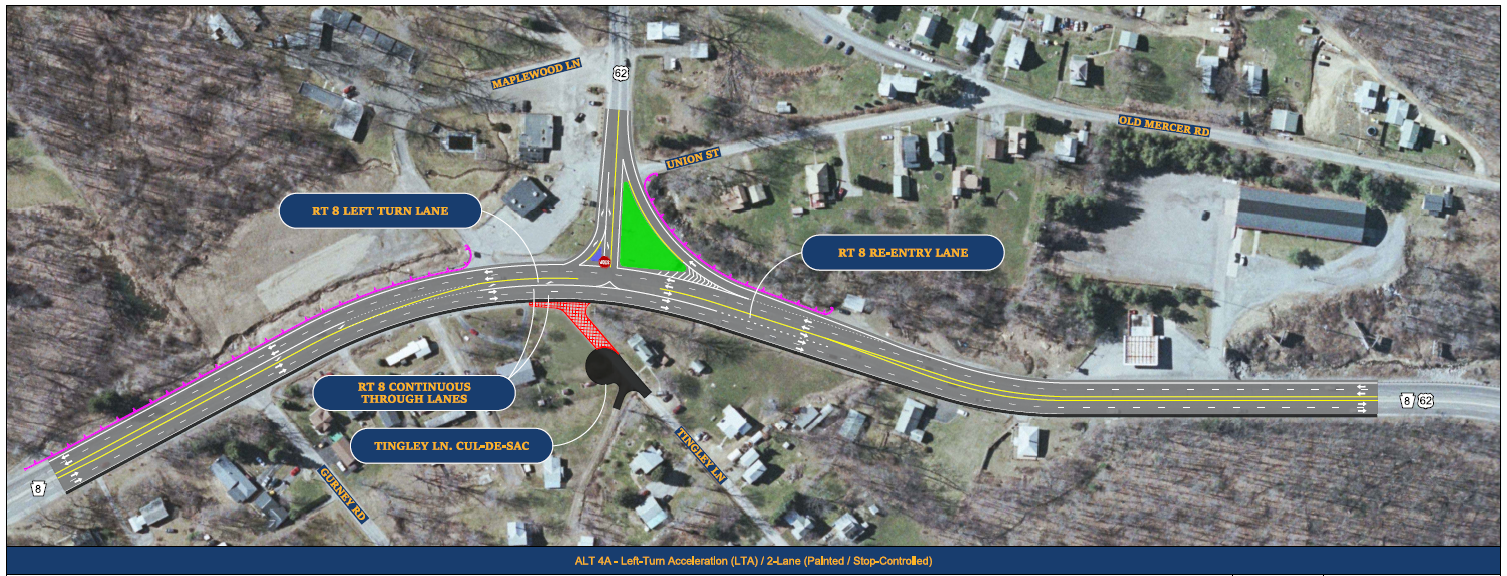
ALT 4A – Like the previous alternatives 3A and 3B, this alternative focuses on creating a separate dedicated entry lane for traffic turning left from Route 62 onto Route 8. However, while the previous options accommodate that entry lane by reducing northbound Route 8 to just a single lane of through-traffic at the intersection, this version maintains two continuous through-traffic lanes down the hill. ALT 4A, specifically, uses only pavement markings and channelization devices to create the new lane configurations, compared to other options that rely on the installation of low-curb medians. Tingley Lane would again possibly be turned into a cul-de-sac, or at least restricted to right-in/right-out traffic only.
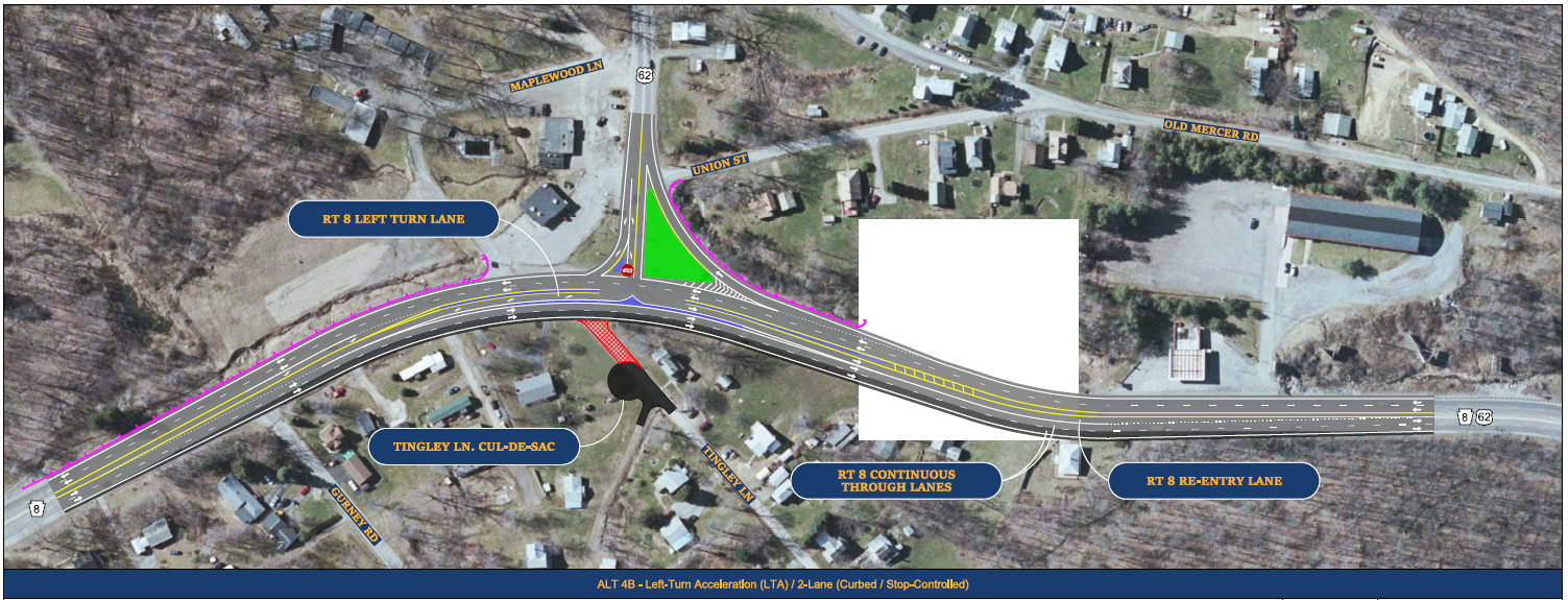
ALT 4B – This alternative is similar to the previous ALT 4A, including a focus on creating a separate dedicated entry lane for traffic turning left from Route 62 onto Route 8, and maintaining two continuous through-traffic lanes along northbound Route 8 down the hill. However, while the previous option used only pavement markings and channelization devices to create the new lane configurations, this version widens Route 8 through the intersection to install low-curb medians, similar to the approach used in ALT 3A. As with other alternatives, Tingley Lane would possibly be turned into a cul-de-sac, or at least restricted to right-in/right-out traffic only.
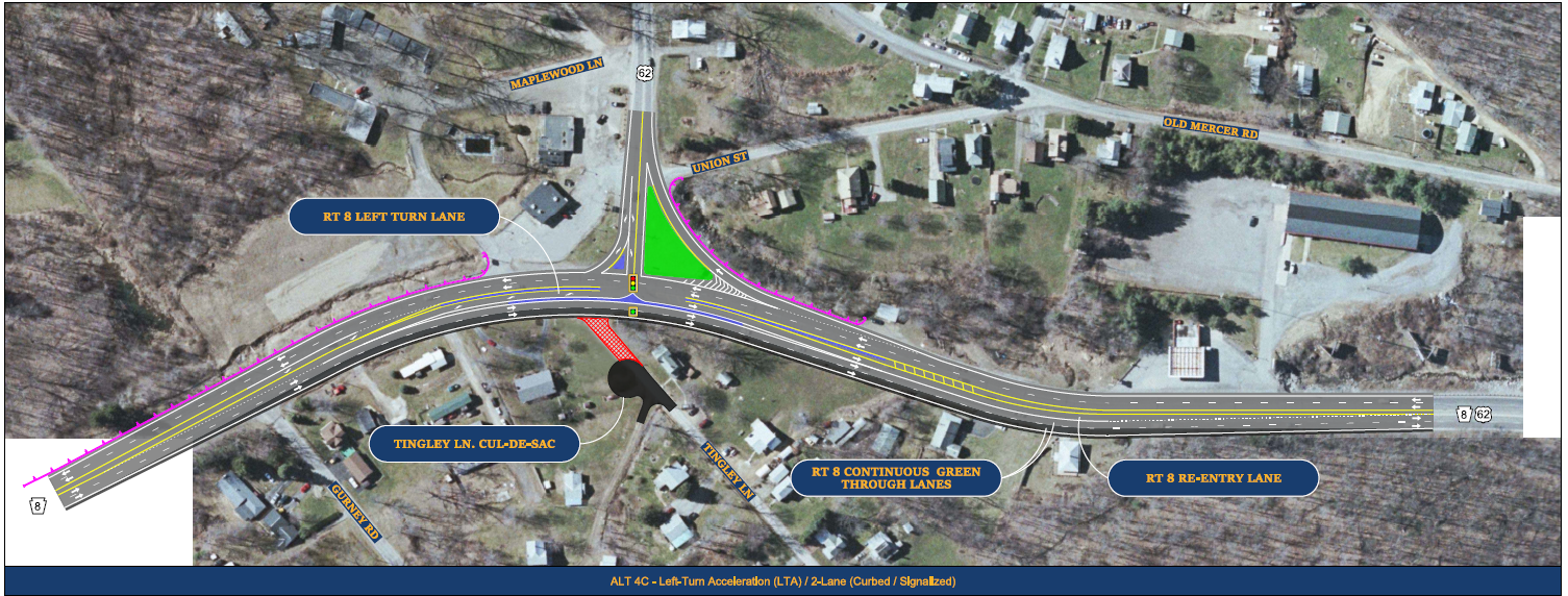
ALT 4C – This alternative is identical to the previous ALT 4B, but adds a traffic signal in lieu of stop signs to control movements for Route 62. The traffic signal would only control movements from Route 62, from northbound Route 8 onto Route 62, and uphill along southbound Route 8. Two lanes of northbound Route 8 though through traffic headed down the hill would have a continuous green light. Tingley Lane would again possibly be turned into a cul-de-sac, or at least restricted to right-in/right-out traffic only.
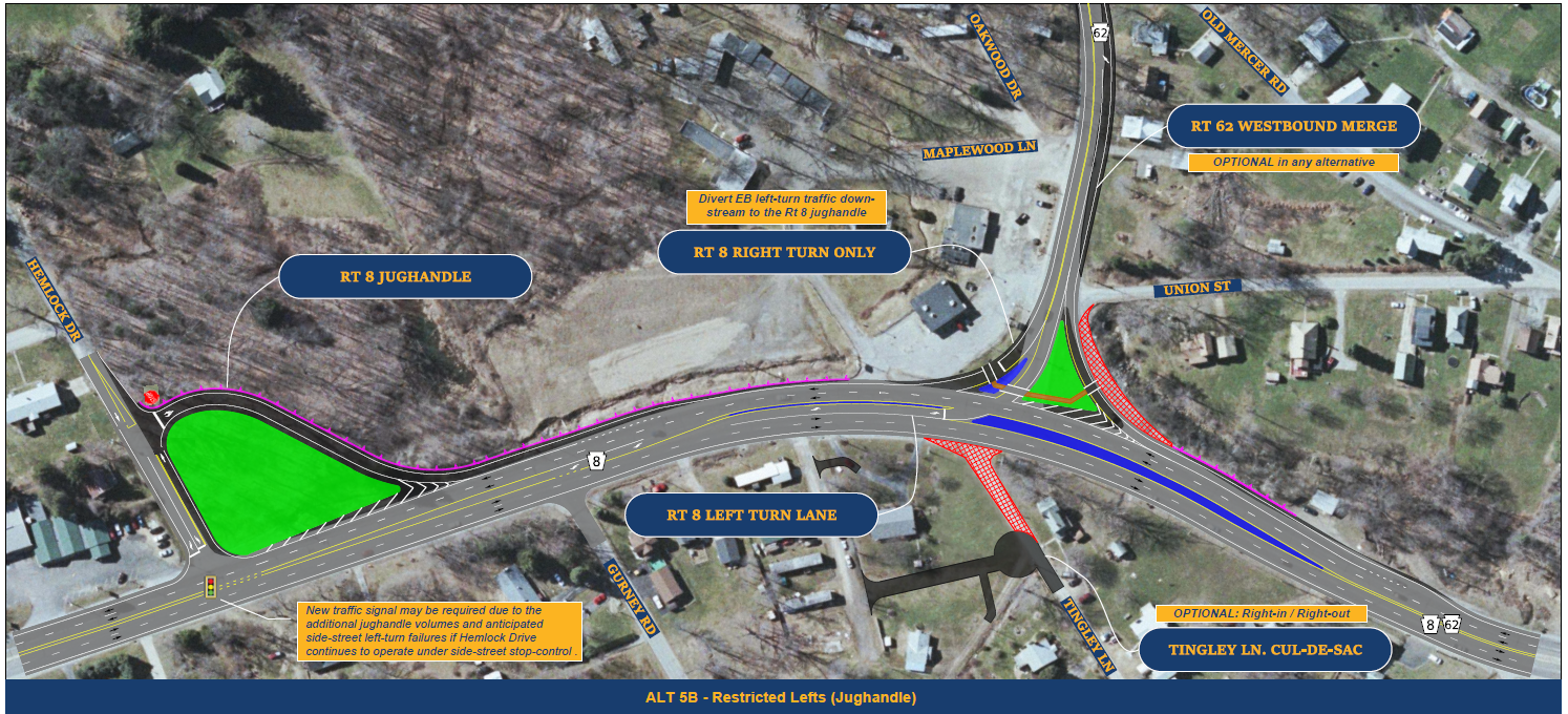
ALT 5B – This alternative creates a new jughandle configuration for drivers wanting to turn from Route 62 onto Route 8. No left-turns would be permitted from Route 62. Instead, all traffic from Route 62 would turn right at the intersection, but traffic with a final destination of northbound Route 8 (toward Franklin) would use a new jughandle turnaround at Hemlock Drive. A new traffic signal may be required at the intersection of Route 8 and Hemlock Drive to ensure efficient operations with the added turnaround traffic. Concrete islands and additional modifications would also be required at the Route 8 and Route 62 intersection to implement the new turning restrictions, and may also refine the merge area and pedestrian crosswalks on Route 62. As with other alternatives, Tingley Lane would possibly be turned into a cul-de-sac, or at least restricted to right-in/right-out access only.
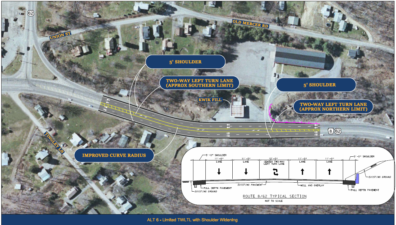
ALT 6 – This alternative widens the shoulders along Route 8 north of the intersection and reconfigures pavement markings and the median area to create a new center, shared left turn lane near the existing Kwik Fill gas station and adjacent property driveways. The left-turn lane can then be used to provide a refuge area for vehicles waiting to turn off of Route 8 in either direction, which removes those vehicles from the northbound and southbound Route 8 through-traffic lanes to reduce potential conflicts with or interruptions to traffic moving up or down the hill.
Project Presentation
Please view the short video below for a presentation on some of the highlights of the study presented during the first public meeting held November 2020.