The use of Unmanned Aerial Systems (UAS), also known as drones, is taking off around the country for both private and public use. For PennDOT, and other state DOTs, drones offer a unique approach to solving a myriad of complex issues and have proven to be a useful and necessary tool in the transportation toolbox.
For PennDOT, UAS really took off when it decided to champion the innovation as part of the Federal Highway Administration's (FHWA) Every Day Counts Round 5 (EDC-5) in 2018.
From the beginning, PennDOT's UAS program has explored a variety of uses for these units. Drones have been deployed for structural, construction and stormwater mitigation inspections, surveys, traffic analysis, incident management and during disaster response, saving time and resources.
To position Pennsylvania as a place to safely test and deploy UAS technology, a public-private UAS Task Force was created in 2018 and charged with developing a multi-year strategic plan to establish a framework for identifying, integrating and managing UAS technologies. FHWA State Transportation Innovation Council (STIC) Incentive Program funding helped the task force develop the strategic plan along with manuals and a robust training program to ensure PennDOT staff and approach to UAS meet Federal Aviation Administration (FAA) safety regulations.
To date, PennDOT has nearly 30 licensed UAS pilots statewide and 36 UAS units. PennDOT has also trained and certified over 100 third-party UAS pilots to fly missions for PennDOT.
Pilot projects have allowed for further evolution of the UAS program at PennDOT.
In District 11, which encompasses Allegheny, Beaver and Lawrence counties, PennDOT and its consultants conducted monthly flights to monitor the progress of the I-579 Cap Urban Connector Project, which was the recipient of the 2022 America's Transportation Awards national Grand Prize. The park project, which reconnected a community divided by an interstate several decades ago, consists of a new "cap" park structure spanning over a portion of I-579.
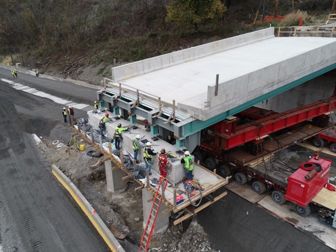
As part of the Kenmawr Bridge Replacement Project in Allegheny County, UAS flights were typically conducted monthly or as needed for critical work items. Using the "Reconstruct" software, a PennDOT consultant used the output from the flights to generate a 3D model, which was then tied to the project schedule to monitor progress. The "Reconstruct" software was also used to monitor progress on the construction of a roundabout on McLaughlin Run Road in Upper St. Clair Township, Allegheny County.
District 11 is also currently piloting use of the "Datumate" drone mapping software on the Freedom Road roundabout project in Beaver County. The software can be used to measure the cut and fill areas, distances within the project, trim cross sections and note safety as well. It can be used for clash detection, to calculate earthmoving volumes and cross section design. The software helps to track progress to see if a portion of the projects is on track, close to being behind or late.

.jpg)
Other PennDOT districts continue to ramp up their UAS efforts as well. District 6, based in southeastern Pennsylvania, is building a robust UAS program using drones for supplemental and progressive construction inspection flights, pre-construction imagery for design activities, high mast inspections, and storm damage surveys. More recently, District 6 used a drone to monitor progress on the I-95 bridge collapse's cleanup and reconstruction efforts.

 The district has also used drones to conduct a rockslide evaluation along I-476 and tested live streaming of drone flights in Microsoft Teams.
The Pennsylvania Turnpike Commission (PTC) also used $50,000 in STIC Incentive Program funding from FHWA to assist in the purchase of four UAS vehicles that were transferred to the Pennsylvania State Police (PSP) for crash reconstruction work. The PTC also purchased an additional four UAS units for its own purposes. The drones have been a valued addition to their equipment and resulted in significant time savings and shorter road closures as the PSP needs less on-scene time during incidents and can map accidents without having to close the road.
PennDOT is not alone in their drone advancement efforts and frequently collaborates with other states to exchange information, ideas and lessons learned. PennDOT's next steps to further evolve the program include additional outreach, review of software being piloted, addressing UAS data storage challenges, expansion of PennDOT's drone fleet, which includes the recent purchase of 13 Skydio drones, and publication updates.