Begin Main Content Area

 Content Editor

PennDOT Pathways I-83 South Bridge Online Meeting - October 2021

I-83 South Bridge Project

Virtual Public Meeting

This page is best viewed in Chrome, Edge or Firefox.

PennDOT welcomes you to the second Virtual Public Meeting for the I-83 South Bridge Project. Click the video below for an introduction to the project:

Click here to download a PDF transcript of the video.

Thank you for joining us to learn more about the I-83 South Bridge Project. We're here to provide information about the project's detailed design plans, environmental and community impacts, potential tolling implementation, and project schedule.

You can access this meeting anytime between October 25 at 12:00 p.m. and November 24, 2021, at 11:59 p.m. at your convenience.

We encourage comments on the project. Comments will be accepted through November 24 when the meeting closes.

Comments may be submitted via the comment form at the bottom of this meeting's web page, via email to i83SouthBridge@pa.gov, by leaving a message on our hotline at (717) 743-1005 or by sending a letter to I-83 South Bridge Project, Attn: Derek Mitch, PennDOT District 8, 2140 Herr Street, Harrisburg, PA 17103.

How To Navigate This Meeting

To advance to the next portion of the meeting, scroll down or use the navigation bar at the top of the page to revisit any part of the meeting.

Project Overview

Project History

The I-83 John Harris Memorial (South) Bridge was built in 1960, and widened in 1982. The bridge connects downtown Harrisburg to its neighboring communities to the west in Cumberland County, and serves as a vital connection for the region. The bridge currently carries more than 125,000 vehicles over the Susquehanna River every day.

I-83 Corridor Master Plan

The I-83 South Bridge Project is part of the larger I-83 Corridor Master Plan. Prepared in 2003, the Master Plan identified several sections of I-83 that needed to be upgraded to meet traffic demands in the area. Specific independent projects identified in the Master Plan included the I-81/I-83 junction to Union Deposit Road, the Eisenhower Interchange, Eisenhower Interchange to the River, and improvements on the West Shore of the River to the I-83/PA-581 split. The Master Plan also identified the requirement for widening and reconstructing the South Bridge.

In 2019 and 2020, PennDOT conducted the Greater Harrisburg Area Susquehanna River Bridges Master Plan to prioritize bridge improvements across the Susquehanna River. During the study, it was determined that the South Bridge was approaching the end of its serviceable lifespan more quickly than originally anticipated. The serviceable lifespan of a bridge refers to the ability to fix a bridge with repairs versus needing to replace the structure entirely. When a bridge reaches the point in its age and use that it requires frequent, costly repairs that will shut down all or part of the bridge to traffic regularly, it has reached the end of its serviceable lifespan.

Comparing the traffic analysis conducted for the I-83 Master Plan to the analysis conducted for the River Bridges Master Plan showed that traffic has increased more quickly than was originally predicted. These higher traffic volumes cause greater wear and tear on the bridge, contributing to the bridge reaching the end of its serviceable lifespan. For these reasons identified in the 2020 River Bridges Master Plan analysis, full replacement of the South Bridge is proposed.

Study Area Map

The study area for the South Bridge project spans both Dauphin and Cumberland counties. The eastern project terminus is the eastern touchdown of the bridge on the east shore. The study area includes the South Bridge over the Susquehanna River and extends to the western terminus at the I-83/PA-581 split. The project includes widening and full replacement of the South Bridge, widening and reconstruction of I-83 on the west shore, and reconfiguration of the Lemoyne interchange.

Purpose & Need

At 61 years old, the South Bridge is nearing the end of its serviceable lifespan. This means that wear and tear has caused the bridge to require more frequent and costly repairs.

The purpose of the I-83 South Bridge Project is to improve traffic flow and safety in the Harrisburg metro region. The project is currently undergoing environmental studies to complete the Environmental Assessment.

Several needs have been identified that the South Bridge project is intended to address:

The bridge's aging structure

The bridge is approaching the end of its serviceable lifespan. This means that in the near future, wear and tear on the bridge will cause the need for more frequent and costly repairs. In addition, most of the pavement on the project corridor is over 50 years old.

Current and increasing traffic volumes

The current bridge and roadway do not adequately support today's traffic and won't be able to handle future traffic volumes.

Need for design improvements

The existing roadway system is outdated and in need of updates to meet current design standards.

Lack of bicycle and pedestrian mobility

On the west shore, I-83, the existing interchange design and the location of the railroad hinder the ability for people walking and cycling to access communities and businesses north and south of the interstate and railroad.

Project Design

Alternative Development

In determining how to address the needs of the project, several constraints were taken into consideration:

  • The Dock Street Dam is north of and in close proximity to the South Bridge particularly at the eastern end of the bridge; widening or replacement to the north of the existing structure would not be reasonable as it would impact the dam.
  • The bridge currently carries over 125,000 vehicles per day and is congested during peak rush hour periods; maintaining traffic during construction is of concern.
  • Constructing the new northbound lanes to the south of the existing structure while maintaining traffic on the existing bridge makes sense. Traffic can then be shifted to the new structure, while the existing bridge is demolished, and the new southbound lanes built in its place and traffic redistributed.
  • At the touchdown of the bridge on the east shore, constraints to consider during construction include: the Shipoke Historic District, Capital Area Greenbelt trail, Amtrak and Norfolk Southern rail lines, and the the Front Street Sewage Pumping Station facility.

When designing how the new expanded bridge would tie into existing roadways on the west shore, we addressed several key considerations.

  • Since the bridge is proposed to be widened to the south, I-83 on the west shore would also need to be widened to the south.
  • Widening I-83 to the south would require realignment of Lowther Street, shifting it behind the buildings on the east end of Lowther to connect at Susquehanna Court. By realigning Lowther Street, access to the Lemoyne Borough wastewater facility and offices in the area would be maintained without routing traffic through the neighborhood on Walton Street.
  • The Norfolk Southern Railroad parallels I-83 to the north constraining the redesign of the interchange on the west shore.
  • Due to the widening of I-83 on the west shore, the South Third Street bridge over I-83 would need to be lengthened to accommodate additional lanes under the bridge. An offline replacement of the South Third Street bridge is proposed to allow for traffic to be maintained on the existing bridge during construction. With this relocation of South Third Street, the on-ramp to I-83 North would be shifted to the west beyond South Third Street, in the same location it had been before the 2015 redesign. The on-ramp would need to be shifted to accommodate the proposed I-83 widening and realignment of Lowther Street.
  • The off-ramp from I-83 South would run parallel to the interstate, crossing over the railroad tracks before intersecting with South Third Street near Plum Street.

Proposed Project Design

Since the last public meeting for the I-83 South Bridge Project in February/March 2021, the proposed project design has continued to progress.

Click to view map larger.

Bridge Construction

Typical sections showing the phases of traffic flow during construction are shown below. You can see that the proposed bridge design is widened to accommodate future growth in traffic volumes and has wider shoulders to increase safety on the bridge.

Current Bridge

This is the existing I-83 South Bridge.

Cross-section of a bridge with four lanes going northbound and three lanes southbound.
Bridge During Construction

New northbound lanes would be built first, south of the existing structure. Once complete, all traffic would be routed to these new lanes. The existing bridge would then be demolished, and new southbound lanes would be built where the existing bridge was.

Cross-section of two bridges. On the left is the existing bridge with four lanes north and three lanes south. On the right is the new bridge, with three lanes both directions.
Bridge After Construction

Once the new southbound lanes are complete, the new South Bridge would be finished. At this time, traffic would be redistributed to their appropriate lanes.

Cross-section of two bridges. On the left is five lanes all southbound and the right is five lanes all northbound.

South Third Street Bridge

To accommodate I-83's wider design the South Third Street bridge would need to be lengthened. Given the volume of traffic on South Third Street, the bridge would be reconstructed immediately east of the existing bridge, allowing traffic to use the existing bridge during construction. The eastern replacement minimizes impacts to businesses in the area. This bridge widening would improve bicycle and pedestrian accommodations and connectivity in the area. You can view the proposed changes in the typical section below.

Current South Third Street

This is the existing South Third Street Bridge.

Cross-section of a bridge with a sidewalk protective fence and narrow separated sidewalk on one side, narrow shoulders, two lanes southbound and one lane northbound.
South Third Street After Construction

The proposed design includes wider shoulders and sidewalks to accommodate pedestrians and bicyclists.

Cross-section of a bridge with sidewalk protective fenches and a sidewalk on both sides, wider shoulders, two lanes southbound and two lanes northbound.

Bridge Aesthetics

What will the new South Bridge look like?

The final design plans are not complete, but here are some sample renderings of what the new South Bridge might look like.

Alternative A is a multi-girder bridge alternative, which could use either concrete or steel girders. A few views of the Alternative A design are shown below.

Bird's eye view in daytime of multi-girder bridge alternative from the west shore.

Closeup from the Riverwalk on the east shore during daytime of multi-girder bridge alternative.

Dock Street dam shown on the right side of the image.

Closeup from the Riverwalk on the east shore during nighttime of multi-girder bridge alternative.

Dock Street dam shown on the right side of the image.

Closeup from the Riverwalk on the east shore at sunset of multi-girder bridge alternative.

Dock Street dam shown on the right side of the image.

Alternative B is a concrete segmental box bridge design. A few views of the Alternative B design are shown below.

Bird's eye view in daytime of concrete segmental box bridge design from the west shore.

Closeup from the Riverwalk on the east shore during daytime of concrete segmental box bridge design.

Dock Street dam shown on the right side of the image.

Closeup from the Riverwalk on the east shore during nighttime of concrete segmental box bridge design.

Dock Street dam shown on the right side of the image.

Closeup from the Riverwalk on the east shore at sunset of concrete segmental box bridge design.

Dock Street dam shown on the right side of the image.

The project design on the west shore and bridge would have a consistent aesthetic design with the rest of the I-83 corridor. The images below show an example of the design aesthetic along the I-83 corridor.

Overall elevation of the bridge spanning I-83. This bridge (SR 22 Jonestown Road) would look very similar to South Third Street over I-83 on the west shore.

Closeup of the architectural treatment and protective fence along the length of the bridge.

Bridge Tolling

Funding

The estimated cost of construction of the I-83 South Bridge Project is between $500 million and $650 million.

PennDOT Pathways is a program to identify and implement alternative funding solutions for Pennsylvania's transportation system. As Pennsylvania's mobility needs have grown, the amount of funding required to support our transportation system has continued to increase. Much of our current funding comes from gas taxes and driver and vehicle fees. While this model worked well in the past, circumstances today have made it unsustainable. With PennDOT Pathways, we're looking for reliable, future-focused funding solutions that will meet our growing needs while serving our communities and all Pennsylvanians for generations to come.

PennDOT currently faces an $8.1 billion gap in highway and bridge funding. This means we aren't generating enough funds to properly maintain, restore and expand our transportation system. PennDOT is taking action to find reliable sources of funding through the PennDOT Pathways program.

For more information about PennDOT Pathways, visit www.penndot.gov/funding.

One of the funding solutions identified in the Planning and Environmental Linkages (PEL) Study is the implementation of bridge tolls on major bridge projects across the state. The I-83 South Bridge Project is one of several projects being evaluated as a candidate for bridge tolling as a part of the PennDOT Pathways Major Bridge P3 Initiative. You can learn more about the program and initiative at the link above.

A bridge toll is a fee that drivers pay when using a specific bridge, often by using a service like E-ZPass. The funds received from this toll would go back to the South Bridge to pay for its construction, maintenance, and operation.

Potential Toll Implementation

To implement the toll with All-Electronic Tolling (such as E-ZPass or toll-by-plate), tolling gantries would be installed to collect tolls from vehicles travelling northbound and southbound across the bridge. These toll gantries would not require drivers to stop to pay a toll when using the bridge but would record vehicles as they pass under the gantry sensor. The toll gantry location is shown on the map to the right.

Signs would be placed prior to the tolling facility in each direction to inform drivers about the toll bridge, as well as at the interchanges and along the local roadway network.

PennDOT has established that tolls on the candidate bridges, including the I-83 South Bridge, would be in the range of $1-$2 for cars using E-ZPass and higher for toll-by-plate and for medium or heavy trucks. Exact tolling amounts would be determined once design plans are finalized so the toll would generate enough revenue for the bridge's replacement and maintenance for a period of approximately 30 years. At the end of the 30-year term for the Public Private Partnership (P3), the tolling facility would be removed.

Qualifying emergency vehicles would be permitted to use Pathways' bridges at no cost, following the Pennsylvania Turnpike Policy (PDF).

It is expected that toll collection on the bridge would begin between 2023 and 2025.

Environmental & Community Impacts

Environmental Assessment

An Environmental Assessment (EA) is a detailed study into how a project would affect the surrounding community's quality of life, including your health, safety, cultural resources, natural resources and more. An EA is being prepared for the South Bridge project to address the requirements of the National Environmental Policy Act (NEPA).

Your input is an important component of the EA. The public is encouraged to provide their comments on the project during this public meeting comment period and at the public hearing, this winter.

Section 106 (Cultural Resources)

Section 106 of the National Historic Preservation Act is applicable to federal agencies and requires identification of, and assessment of effects on, historic properties and archaeological sites listed on, or eligible for listing on, the National Register of Historic Places (NRHP). Consultation with persons interested in the historic and archaeological properties/sites is integral to the Section 106 process and the project's public involvement. The Section 106 process includes identifying an area of potential effect (APE) for the project, and inviting property owners within that APE, as well as historical societies and others to participate in the Section 106 process as "Consulting Parties."" Separate APEs are established for the archaeological investigations and for above-ground historical properties.

The APE for the project was established in October 2020 and a survey was conducted of the identified properties over 50 years old within the APE. A subsequent expansion of the APE in May 2021 included additional properties in the survey efforts. After identification of potential historic properties and submittal of the eligibility materials, the list of historic properties within the APE was finalized to include:

  • Harrisburg Historic District (downtown Harrisburg and Shipoke)
  • Pennsylvania Railroad: Enola Branch Low Grade Freight Line (West Shore along Susquehanna River)
  • Pennsylvania Railroad: Mainline (East Shore in Harrisburg)
  • Harrisburg City Parks 7 Parkway Plan (includes the Greenbelt and Riverfront Park)
  • West Shore National Bank of Lemoyne (Lemoyne Borough)
  • Philadelphia & Reading Railroad: Harrisburg & Pittsburgh Branch (Lemoyne Borough)
  • Grace United Evangelical Church (Lemoyne Borough)
  • Henry T. Simmonds House (New Cumberland Borough)
Click to view map larger.

With the presence of historic properties within the APE, the project has been evaluated in accordance with Section 106 regulations of the National Historic Preservation Act and the Pennsylvania State History Code. Through this evaluation and coordination with the State Historic Preservation Officer (SHPO), it was determined that the project would result in No Adverse Effect to historic properties.

After initial design activities were conducted, areas that were previously undisturbed were investigated for the potential to contain archaeological deposits. All of these areas, within the Archeological APE, were located on the west side of the river, in the vicinity of Lowther Street. No archaeological deposits were found in the geomorphological and archaeological investigations conducted in these areas. In May of 2021, it was determined that there are no archeological resources in the project area.

Noise Analysis

Since new lanes are being added northbound and southbound and the Lemoyne interchange is being reconfigured, the I-83 South Bridge Project is eligible for consideration of noise abatement. A noise analysis was conducted and included noise monitoring of existing conditions and noise modeling for future conditions. Noise modeling was performed to predict noise levels throughout the project area under worst-case, peak-hour traffic conditions.

The noise analysis studies included existing conditions in 2016, conditions in 2050 under a no-build scenario, and conditions in 2050 with the new bridge project design.

Throughout the project corridor, four noise study areas (NSA) approached or exceeded PennDOT and FHWA's Noise Abatement Criteria (NAC) warranting abatement consideration. These are labeled as NSA 2, NSA 3, NSA 4 and NSA6. Based on meeting the criteria, an evaluation of noise abatement was conducted for these four locations.

Through the noise abatement evaluation analysis, it was determined that sound barriers were both feasible and reasonable for two of the locations, NSA 2 and NSA 3. It was determined that noise abatement was not feasible and/or reasonable for the other two locations, NSA 4 and NSA 6.

With these results, additional analyses are recommended for NSA 2 and NSA 3 during the final design phase of the project.

The parameters of warranted, feasibility, and reasonableness are explained below:

  • Warranted: Noise abatement is warranted in areas approaching or exceeding the NAC due to traffic noise at noise-sensitive land uses within the project corridor.
  • Feasibility: Where warranted, noise abatement feasibility looks at the effectiveness of a noise barrier in reducing noise, and the ability to construct without introducing substantial engineering or safety problems to the project.
  • Reasonableness: If noise abatement passes the feasibility test, the reasonableness is evaluated to ensure that a noise barrier is appropriate for a given area or project by assessing cost/benefit, noise reduction goals, and the consideration of viewpoints from the benefitted receptors. If it passes the reasonable test, benefitted receptors of the noise barrier would cast a vote on if they would like to have a noise wall constructed. If the vote passes by a majority, a noise barrier would be constructed.

Air Quality

It is PennDOT's policy to assess the air quality impacts of transportation improvement projects and to give consideration to the incorporation of appropriate avoidance and/or relief strategies into preliminary engineering designs and construction for those projects that have potential air quality impacts. An air quality analysis has been conducted for this project in accordance with US Environmental Protection Agency's (EPA), Federal Highway Administration's (FHWA) and PennDOT's approved Air Quality protocols and procedures. The analysis evaluated the air quality impacts of the project relative to national ambient air quality standards. This includes an analysis of:

  • Whether the project will cause or contribute to a new localized exceedance of carbon monoxide (CO) or particulate matter (PM2.5) ambient air quality standards or increase the frequency or severity of any existing exceedances.
  • The potential for Mobile Source Air Toxics (MSATs) impacts due to the project.
  • The greenhouse gas (GHG) impacts of the project.

After the analysis was conducted, it was determined that the project would have no significant adverse impact on air quality in any of these categories.

Waste Studies

A Phase I Environmental Site Assessment Report (ESA) was conducted for the project study area. The Phase I ESA included record reviews, interviews, site reconnaissance, compilation of data, data evaluation, and recommendations. Seven sites were identified that will require further investigation as the project progresses.

Click to view map larger.

Eight total sites were identified in the project area. Site 8, identified on the map, did not require further investigation as no earth disturbance was anticipated.

Wetland and Stream Studies

Wetland studies were completed for the project and a Wetland Identification and Delineation Report was prepared to meet the regulatory requirements of the U.S. Army Corps of Engineers (USACE) under Section 404 of the Clean Water Act and in accordance with the Pennsylvania Department of Environmental Protection (DEP). In this report, it was identified that the project area includes the Susquehanna River waterway and three river island wetland areas.

Impacts to the river island wetlands are shown in the table below:

River Island Wetlands Impacts Impact
Permanent 0.5 Acres
Temporary 0.11 Acres
Click to view map larger.

The Susquehanna River is a warm water fishery. Migratory fish species are known to move upstream to spawn. These fish pass the Dock Street Dam via notches in the dam, which will be maintained during construction.

Floodplains

The new bridge would not increase the flood elevations in the project area. During construction of the project, access in the river would be needed for constructing the bridge. PennDOT is coordinating with relevant regulatory agencies to minimize flooding impacts due to construction activities.

Threatened & Endangered Plants & Animals

A review determined there are no known impacts anticipated to threatened and endangered plants and animals within the project area.

Right of Way Acquisition

Where the project requires acquisition of ROW, property would be purchased in accordance with the Uniform Relocation Assistance and Real Property Acquisition Policies Act of 1970.

More information can be found in the following publications:

Traffic Diversion Analysis

Traffic diversion analysis comprises two distinct steps: The first is the development of the traffic model to predict how much traffic would divert off the interstate when a toll is imposed and what route that traffic would take. The second step is evaluating and analyzing the diversion routes identified to determine the impact of the diverted traffic on that route and to identify improvements to mitigate those effects.

A detailed traffic demand model was used to identify diversion routes. The existing Tri-County Regional Planning Commission Harrisburg area model that was employed is based on assumptions around the transportation system, regional demographics, and traveler characteristics. These assumptions were then combined using data from traffic counts (including the share of truck traffic), recorded travel speeds and origin and destination patterns, along with regional travel demand models. Both short- and long-term effects were evaluated.

The model is then run under various parameters to predict the amount of traffic that may choose to divert off the interstate and more importantly, where that traffic would go.

If a toll is placed on the I-83 South Bridge Project, an estimated 22% of daily traffic is expected to choose to divert off the interstate to avoid paying the toll, based on the results of the detailed traffic model. The model was also used to analyze what routes they would predominantly take. These would be predominantly passenger vehicles and small trucks.

So where does the majority of the diverting traffic go? The primary diversion routes identified are the I-81 Bridge, I-76 Bridge, Harvey Taylor Bridge and Market Street Bridge. These routes are shown in the map below. You can click on the map to enlarge it.

Click to view map larger.

As you can see from the table below, the PM peak hour traffic on South Bridge would be reduced by approximately 1,800 hour in each direction. What does this mean for the other bridges in the area? The table shows the estimated change in traffic volume across the Harvey Taylor Bridge, I-76 (Turnpike) Bridge, I-81 (Wade) Bridge, and the Market Street Bridge. The vehicles that divert from South Bridge use one of the other four bridge crossings. PM peak hour traffic will increasein the range of 400-500 vehicles per hour in each direction for I-81 and I-76.

Some traffic that was likely using South Bridge to avoid the turnpike toll would return to the turnpike. Harvey Taylor Bridge will see ranges of about 350-670 vehicles per hour, and the Market Street Bridge will see up to 280 vehicle per hour increase in the westbound direction during the PM peak hour. The peak hours are used to evaluate the operations at intersections during the busiest times of the day.

PM Peak Hour

Bridge Direction Pre-Toll Traffic Post-Toll Traffic
South Bridge (Northbound) Eastbound 6,850 5,290
South Bridge (Southbound) Westbound 7,880 6,340
I-81 Bridge (Northbound) Eastbound 4,410 4,920
I-81 Bridge (Southbound) Westbound 6,620 7,090
Harvey Taylor Bridge Eastbound 1,270 1,620
Harvey Taylor Bridge Westbound 1,840 2,510
Market Street Bridge Eastbound 560 840
Market Street Bridge Westbound 940 940*
I-76 Bridge Eastbound 1,800 2,230
I-76 Bridge Westbound 2,320 2,830

*Due to capacity constraints at this intersection during the PM Peak Hour, the model has predicted that volumes will remain the same.

Using the traffic demand model, the origin-destination patterns are also taken into account in looking at diversion. The origin-destination criteria is divided into three categories, local (<10 miles), regional (10-25 miles) and external (<25 miles). As you can see in the graphic below, the majority of the traffic traveling over the bridge is local traffic.

When people hear about vehicles diverting from the interstate to avoid a tolled bridge, they often envision what happens when there is a full traffic detour. To distinguish between a diversion and detour in simple terms, diversions are a choice, detours are mandatory.

Detours are imposed because of construction or an incident on a roadway or bridge and those detours must be followed. In contrast to a detour, diversion from the interstate is a choice that drivers may make to avoid a toll. Diverting traffic for the South Bridge is predicted to be 22 percent, compared to a detour where 100 percent of traffic leaves the interstate.

Traffic Diversion Methodology

Once it was determined how much traffic would divert and the primary routes that would be utilized, a comprehensive evaluation of the impacts to the diversion routes was undertaken. The graphic below highlights the key methodology for the evaluation of the diversion route.

Route Identification
Prioritize routes that add more than 100 vehicles per day
Traffic Projections
No toll vs tolling scenario comparisons
Route Conditions
Intersections, traffic control, signage, & pavement conditions
Crash Data Summary
Identify crash patterns & crash rates
Capacity Analysis
Depict operational issues & capacity limitations
Roadway Review
Evaluation of lane widths and pavement structure
Alternative Transportation Modes
Transit, bus, bike lanes, etc.
Potential Mitigation Options
Evaluation of options to offset impacts to community

A workshop was conducted with key stakeholders in July 2021 to get feedback on the diversion route analysis and collect additional information on routes drivers might take, and potential impacts from diverting traffic. This feedback was incorporated into the traffic diversion analysis and evaluated to identify improvements PennDOT could consider to mitigate effects on the community caused by toll diversion.

Traffic Evaluation and Diversion Route Improvement

An extensive traffic study was conducted of the likely diversion routes, which are varied given the grid-like roadway system in the area, including field observations and stakeholder coordination, traffic counts, capacity analysis, and crash analysis.

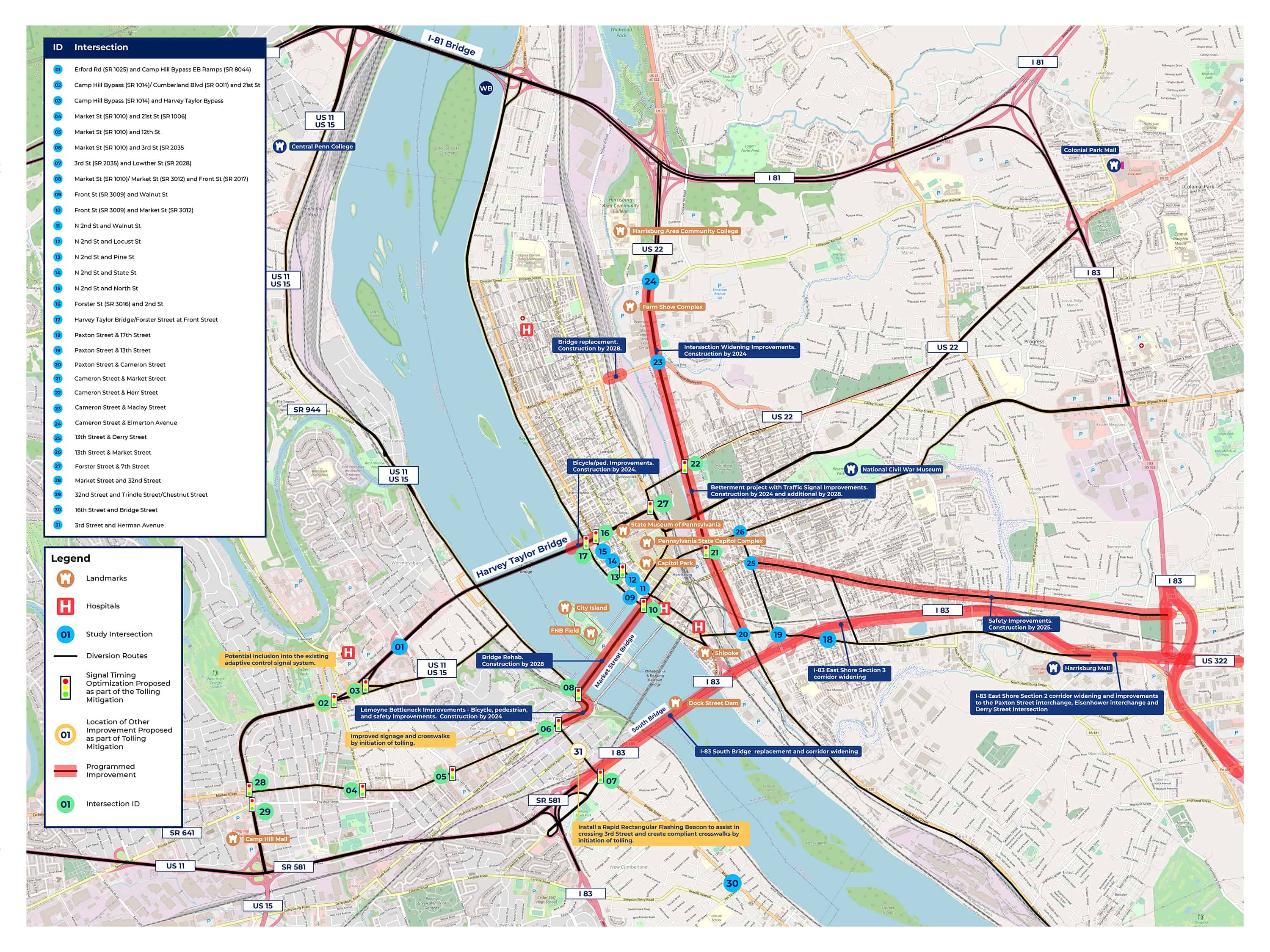
Intersection turning movement counts were conducted at 30 intersections in the vicinity of the I-83 bridge that are likely to be impacted by traffic diverting to avoid tolling, as shown on the Diversion Route Map, during the AM peak and PM peak periods. These count locations were selected by PennDOT to capture the routes expected to be most impacted by traffic diverting from the I-83 bridge due to tolling. These counts included separate tabulations of pedestrians, motorcycles, cars, trucks, medium trucks, and heavy trucks. Video was taken during the counts to document traffic operations.

Capacity analysis was conducted of these 30 intersections using a traffic operations model. Increased traffic along the area roadways as a result of traffic diverting from the I-83 bridge to other alternatives, including primarily the Market Street Bridge and the Harvey Taylor Bridge was estimated using the Tri-County Regional Planning Commission Harrisburg area model.

The capacity analysis indicated that 23 of the study intersections would maintain a similar level of congestion or that congestion increases could be managed with signal timing optimization. At the seven intersections listed below, overall delay is expected to increase in the future with the projected diversions:

  • Erford Road and Camp Hill Bypass [West Shore Intersection #01]- Although the delay will increase, this intersection will continue to operate acceptably.
  • S. 3rd Street and Herman Avenue [West Shore Intersection #31]- Intersection delay will increase, however, based on the roadway grid network, drivers on both sides of S. 3rd Street have access to the existing traffic signal at the intersection of S. 3rd Street and Hummel Avenue, located two blocks north of Herman Avenue. This signalized intersection is an alternative for drivers turning onto S. 3rd Street if the delay at the stop-controlled Herman Avenue becomes excessive.
  • Camp Hill Bypass and Harvey Taylor Bridge Bypass and 21st Street [West Shore, Combined Intersections #02 and #03] - Geometric constraints abutting this intersection make additional improvements impractical.
  • Market Street and Front Street [East Shore Intersection #10] - Physical improvements are impractical given the geometric constraints at this intersection, including the Market Street Bridge and its abutments. It should be noted that while intersection delay will increase at this location, it is expected to be minor.
  • Forster Street and Front Street [East Shore Intersection #17] - Physical improvements are impractical given the geometric constraints at this intersection, including the Harvey Taylor Bridge and its abutments.
  • 32nd Street and Market Street [West Shore Intersection #28] - Physical improvements to this intersection are impractical given the location of development abutting the approaches to this intersection.
  • 32nd Street and Trindle Road/Chestnut Street [West Shore Intersection #29] - Physical improvements to this intersection are impractical given the location of development abutting the approaches to this intersection.

The crash analysis looked at five years' data of reported crashes throughout the study area. Multiple crash clusters have been noted throughout the study area, which is not unexpected given the volumes of traffic and number of conflicting movement throughout the area. The largest clusters are noted on the east side of the Harvey Taylor Bridge at Front Street and along N. Cameron Street, between Elmerton Avenue and Maclay Street.

Programmed Improvements

Several improvements are programmed to be completed within the next few years within the area of the I-83 bridge and the areas expected be impacted by the projected diversion traffic. Notable improvements include the following projects:

  • Cameron Street Improvements - Intersection improvements at Cameron Street/Maclay Street/Arsenal Boulevard and signal improvements along Cameron Street corridor
  • Capital Gateway Improvements - Bicycle/pedestrian improvements along Forster Street from Susquehanna River to 2nd Street
  • Derry Street Safety Improvements - Safety improvements along Derry Street from 13th to 40th Streets
  • I-83 East Shore Sections 2 and 3 - Widening of I-83 to provide additional travel lanes in each direction and improvements to the interchanges from South Bridge to Eisenhower Boulevard (all interchanges). Learn more on the I-83 Beltway Projects website.
  • Lemoyne Bottleneck Improvements - Bicycle, pedestrian, and safety improvements on Market Street, from Bosler Avenue to Front Street.
  • Maclay Street Bridge - Bridge replacement over the Norfolk Southern railroad
  • Market Street Bridge - Bridge rehabilitation over Susquehanna River
Key Issues

Through input provided at the diversion workshop and through the traffic analysis and crash evaluation, several issues have been identified throughout the project study area. The following is a listing of the major identified issues along with a brief discussion on how those issues are expected to be addressed.

Market Street operation in Lemoyne [West Shore]

  • Issue - Traffic signal operation creating bottlenecks
  • Resolution - Construction of the Lemoyne Bottleneck Improvements project should improve the bicycle and pedestrian operations in this area of Market Street.

Forster Street, at Front Street and 2nd Street [East Shore]

  • Issue - Overall traffic operation issues
  • Issue - Bicycle and pedestrian safety
  • Resolution - Traffic operations and overall safety should be improved with the Capital Gateway Improvements Project and traffic signal optimization proposed in conjunction with the I-83 bridge tolling.

Cameron Street and Maclay Street/Arsenal Boulevard [East Shore]

  • Issue - Overall traffic operation issues
  • Resolution - Construction of the Cameron Street Improvements project should improve the traffic operations along Cameron Street.

Select West Shore signalized intersections [West Shore]

  • Issue - Overall traffic operations
  • Issue - Inadequate traffic signal coordination
  • Resolution - Signal timing optimizations proposed in conjunction with the tolling, which include coordination improvements, should improve overall traffic operations in this area.

PA 581 merge with WB I-83 [West Shore]

  • Issue - Short merge creates traffic backups
  • Resolution - Diversion of traffic away from I-83 due to the tolling will reduce I-83 traffic volumes, which will improve the operation of this merge.

32nd Street at Market Street and Chestnut St/Trindle Road [West Shore]

  • Issue - Overall intersection operation
  • Resolution - Traffic signal timing improvements should help alleviate this concern. Development constraints adjacent to this intersection limit the ability for further improvement.

Front Street and Market Street [East Shore]

  • Issue - Overall intersection operation
  • Resolution - Traffic signal timing improvements should help alleviate this concern. Geometric constraints adjacent to this intersection limit the ability for further improvement.

S. 3rd Street at Herman Avenue [West Shore]

  • Issue - Bicycle/pedestrian safety to cross S. 3rd Street due vicinity of pool and park
  • Resolution - Installation of Rectangular Rapid Flashing Beacon (RRFB) should help improve the visibility of the crosswalk and people crossing S. 3rd Street at this location within the crosswalk.

Camp Hill Bypass/Harvey Taylor Bridge Bypass and 21st Street [West Shore]

  • Issue - Overall intersection operation
  • Resolution - Traffic signal optimization and potential inclusion of this intersection within the Camp Hill Bypass adaptive signal system should help improve the operation of this intersection. Development and geometric constraints limit the ability of additional improvements at this location.

N. 7th Street and Walnut Street [West Shore]

  • Issue - Crossing guard safety given crash history
  • Resolution - Coordination with the municipality to improve crosswalk striping and signage to be in conformance with current standards should provide improvement at this location.
Proposed Diversion Route Improvements

In summary, the following is a listing of the proposed diversion route improvement measures proposed in conjunction with the I-83 bridge tolling:

  • Traffic Signal Optimization:
    • Market Street and 21st Street [West Shore Intersection #4]
    • Market Street and 12th Street [West Shore Intersection #5]
    • Market Street and 3rd Street [West Shore Intersection #6]
    • 3rd St and Lowther Street [West Shore Intersection #7]
    • Market Street and Front Street [West Shore Intersection #8]
    • Front Street and Market Street [East Shore Intersection #10]
    • 2nd Street and Pine Street [East Shore Intersection #13]
    • Forster Street and 2nd Street [East Shore Intersection #16]
    • Front Street and Forster Street [East Shore Intersection #17]
    • Cameron Street and Market Street [East Shore Intersection #21]
    • Cameron Street and Herr Street [East Shore Intersection #22]
    • Forster Street and 7th Street [East Shore Intersection #27]
    • 32nd Street and Market Street [West Shore Intersection #28]
    • 32nd Street and Chestnut Street/Trindle Road [West Shore Intersection #29]
  • Install flashing beacon at S. 3rd Street and Herman Avenue for pedestrian/bicycle crossings of S. 3rd Street [West Shore Intersection #31]
  • Review clearance interval timing at Forster Street and Front Street [East Shore Intersection #17]
  • Coordinate with municipality to improve crosswalk paint and signage near N. 7th Street and Walnut Street [West Shore]
  • Consider incorporation of the intersection of Camp Hill Bypass/Harvey Taylor Bridge Bypass/21st Street into Camp Hill Bypass Adaptive Signal System [West Shore Intersections #21 and #22]
  • Conduct before/after study of intersection operations - Because modeling forecasts can sometimes differ from actual impacts, before and after studies will be conducted on the diversion routes. These studies will confirm the models' results or identify areas where additional evaluations should be conducted to identify improvements for consideration and potential implementation.
Click to view map larger.

Environmental Justice Considerations

Executive Order 12898, Federal Actions to Address Environmental Justice in Minority and Low-Income Populations (February 11, 1994), directs federal agencies to identify and address, as appropriate, disproportionately high and adverse human health or environmental effects of programs, policies and activities on minority and low-income populations.

  • Low-income is defined as a person whose median household income is at or below the Department of Health and Human Services (DHS) federal poverty guidelines ($26,500 for a household of four).
  • Minority is a person who is: (1) Black (2) Hispanic or Latino (3) Asian American (4) American Indian and Alaskan Native, or (5) Native Hawaiian and Other Pacific Islander.

Potential implementation of a toll would affect all bridge users regardless of income and minority status. Because tolls would comprise a larger percentage of a low-income bridge user's income, tolls would have a greater effect on these users, particularly if they depend on the bridge for daily travel to work or other destinations. As a result, and in keeping with other DHS financial assistance programs offered in Pennsylvania (SNAP, Medicaid, LIHEAP), PennDOT is proposing to offer toll-free bridge access to low-income persons qualifying for one or more of these DHS programs. The DHS financial assistance programs use a progressive income limit based on the number of people in a household (equivalent to about $35,000 for a family of four – but it varies slightly by DHS program). Individuals who qualify for toll-free bridge access would select one toll bridge from the Major Bridge P3 Initiative to apply these benefits.

As a result of PennDOT's tolling policy explained above, no adverse effects on low-income bridge users are expected to result from implementation of a new toll. PennDOT would implement an extensive public outreach program to provide information on the tolling policy and assist low-income and minority populations in the application process to enter the program and benefit from the tolling policy.

Preliminary analysis, U.S. Census data, and information received from PennDOT outreach initiatives indicate that low-income and minority populations are prevalent throughout the area where traffic diversions would occur. PennDOT is seeking participation by all potentially affected communities in order to understand how the effects of increased traffic may impact low-income and minority populations. You are encouraged to contribute to our understanding of local conditions by submitting your comments using the comment form at the end of the meeting.

The map below shows low income and minority areas in the community. The identified potential diversion routes are shown in pink on the map.

Click to view map larger.

Project Schedule

The project's next step is to complete the environmental studies and prepare the Environmental Assessment (EA) for the project. The EA will be made available for public review and comment, which is expected to happen in Winter 2021/2022. At this time, a Public Hearing will be held for the project.

Construction of the project is not expected to begin until 2025, with a target completion date in 2032. Here, you can see an estimated timeline of the project's major milestones:

Anticipated Pre-Construction and Environmental Assessment Milestones

Timeline depicting project scoping in September 2020, first public meeting in winter 2020/2021, second public meeting in fall 2021, and the public hearing and 30-day comment period, as well as an environmental decision in winter 2021/2022.
Click here to view larger.
Timeline depicting project scoping in September 2020, first public meeting in winter 2020/2021, second public meeting in fall 2021, and th epublic hearing and 30-day comment period, as well as an environmental decision in winter 2021/2022.
Click here to view larger.

Estimated Project Construction Milestones

Timeline depicting final designa nd right of way from 2022-2025, potential tolling begins 2023-2025, and anticipated construction start date in 2025.
Click here to view larger.